|
|
Editorial The
Big Picture: Western Drought Intensifies
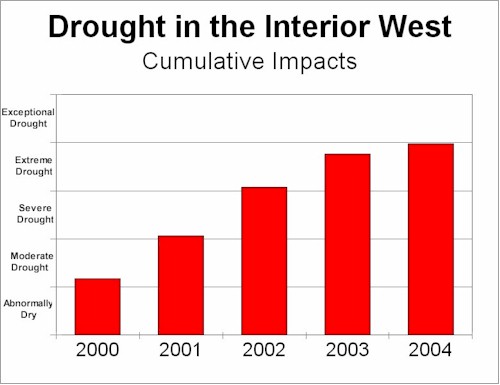
If you thought that western drought conditions in 2003 were bad, then fill your canteens now - because 2004 is shaping up to be worse! For additional information on how the interpretations in the above graph were derived, and a state-by-state chart, CLICK HERE. While the "U.S. Drought Monitor" indicates some improvement over last year, and the "U.S. Seasonal Drought Outlook" predicts some additional localized improvement as the year progresses; both present relatively short-term information strongly weighted towards expected production of annual crops such as wheat and corn, and the availability of irrigation water. Viewed from a longer term ecological perspective, conditions in 2004 may well prove to be the worst since the Great Dust Bowl. Conditions in some localized areas may even be worse than were experienced then. It has been my experience that, at a landscape scale throughout the west, March is the make-or-break month when it comes to drought. Areas that are experiencing significant drought at the end of March can expect little improvement as the growing season progresses due to a number of factors. The majority of the precipitation season is past by then in the northern portions, so little improvement is likely. Even if substantial rains do occur after the end of March, they frequently come after perennial grasses have entered their summer dormancy - or come as high-intensity localized events with heavy runoff and little improvement of soil moisture. There is a greater probability of significant rains further south with summer monsoons from the Gulf of Mexico (generally beginning about July 4th), but these are even more likely to be localized high-intensity events that may produce flash-flooding with only limited improvement in soil moisture. While perennial grasses in that area are mostly warm-season and do not enter summer dormancy during wet or normal years, they do frequently enter drought induced dormancy during dry years. This frequently produces a situation where just enough rain is received for the perennial grasses to break dormancy (drawing upon their root reserves to do so), but the next rain is not received until after they have gone into drought dormancy again. This can happen several times during the growing season. The result of this vicious cycle can be a year with above normal precipitation and below normal production! Any way that you cut it, 2004 is not looking good for the interior West. You can also probably toss at least 2005 and even 2006 into that same pot since a drought of the duration and magnitude that we are experiencing now will require several years of normal and above normal precipitation for full recovery.
|